|
GOTM9 Index Items below this point
Known Bugs and Glitches |
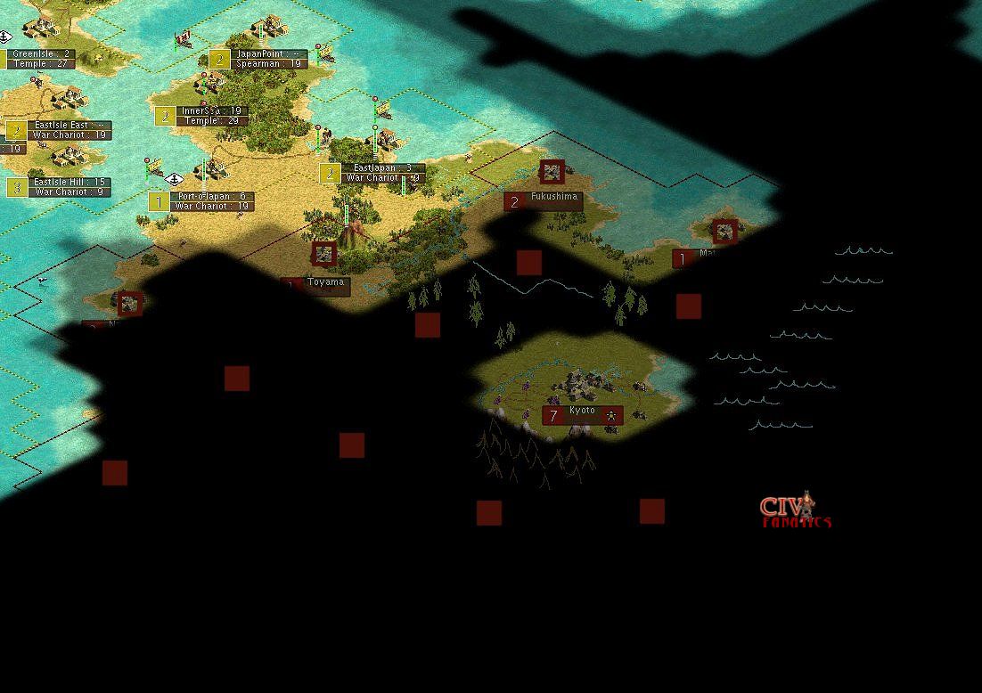
Unit Planning Another key element of the plan to use War Chariots was factoring in the probability of retreat survival during combat. Since War Chariots would retreat when losing a combat event about 50% of the time, this would reduce their effective attack strength but increase their combat survival rate. If the attacks could be staged in waves that would allow the War Chariots to win battles through overwhelming numbers and then take time to heal, each three war chariots could effectively win a battle against spearmen once in every three turns. With this knowledge, the military build up plan, focused on building as many war chariots as possible with a few horsemen in the mix to deal with the possiblities of enemy units in restricted terrain. The very early build cycle for Egypt had produced a number of Warriors that could be upgraded to Swordsmen once Iron Working had become available. The plan was to build few if any swordsmen directly and just to rely on upgraded units for the added strength of swordsmen if necessary. A key planning point for the campaign was to keep supporting units like spearman and swordsmen close behind the advancing War Chariot units to protect work gangs of industrious workers that would throw down continuous roadways to speed up the arrival of reinforcing units. Planning for Terrain Strongest City : Looking closely at the revealed view of Kyoto, I could see four wine resources plus at least one Cow and at least one Game bonus resource. This was a real power house city on grassland and I could not imagine an example where there would be two cities this strong located in the same core area for Japan. This analysis confirmed Kyoto as the primary direct target of any possible attack scenario in order to deprive Japan of what my guess would be as it strongest and most productive city. After taking a careful look at the city view of Kyoto that we could see when our embassy was established, I determined that forested areas existed to the northeast and northwest of the city while there was a high probability of a massive block or wall of mountains to the south of Kyoto. The coastal area to the east of Kyoto could have been a lake, but I was going to guess it was a bay indicating the eastern coast of the Japanese homeland. In the map below, I have sketched in my guesses at the terrain features and the sketched in guesses as to possible town positions based on the known locations of the five towns we can see as well as the observed paths of the units and settlers that emerged out of the fog.
The guessed positions of the cities and towns were important because hopefully we would be able to access and use the Japanese road network fairly early in the campaign. Also because Japan was a military strength civilization, we would hope to find barracks in some of the core cities surrounding Kyoto and this would let us hopefully capture the facilities and speed the rate at which our units healed in preparation for the final assault on Kyoto. The list of Japanese cities in 130 AD could be obtained for free from the foreign advisor trade negotiation screen and included: Other related topics:
|
 ©
2002 by cracker@CivFanatics.com
©
2002 by cracker@CivFanatics.com
All rights reserved. Please read the Terms
of Use.
Send mail to our webmaster with technical
questions about or potential problems with this web site.

 attack and defense values as the horseman unit that would normally replace the War Chariot. The advantage in this case
was in the cost of the unit which at only 20 shields would provide a cost advantage when compared to horsemen
produced by the computer AI players on Emporer level at the cost of 24 shields per unit. Carefully review of the
War Chariot unit abilities also revealed that it was classified as a wheeled unit which would prevent it from entering
into mountainous of jungle terrain if a road were not present. This last feature could be a significant restriction.
Because War Chariots would have the same cost as Archers at 20 shields per unit but would have 1 less movement point,
we planned to build no archers at all.
attack and defense values as the horseman unit that would normally replace the War Chariot. The advantage in this case
was in the cost of the unit which at only 20 shields would provide a cost advantage when compared to horsemen
produced by the computer AI players on Emporer level at the cost of 24 shields per unit. Carefully review of the
War Chariot unit abilities also revealed that it was classified as a wheeled unit which would prevent it from entering
into mountainous of jungle terrain if a road were not present. This last feature could be a significant restriction.
Because War Chariots would have the same cost as Archers at 20 shields per unit but would have 1 less movement point,
we planned to build no archers at all.